Файл:Aral sea.gif
Исходный файл (720 × 720 пкс, размер файла: 3,16 Мб, MIME-тип: image/gif, закольцованный, 12 фреймов, 12 с)
| Cведения об этом файле находятся на Викискладе?, хранилище изображений и мультимедиа для использования во всех проектах Фонда Викимедиа. |
Краткое описание
| Описание |
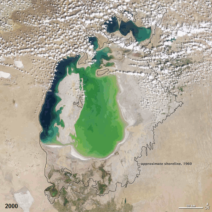
English: In the 1960s, the Soviet Union undertook a major water diversion project on the arid plains of Kazakhstan, Uzbekistan, and Turkmenistan. The region’s two major rivers, fed from snowmelt and precipitation in far-away mountains, were used to transform the desert into fields for cotton and other crops. Before the project, the two rivers left the mountains, cut northwest through the Kyzylkum Desert—the Syrdar’ya to the north and the Amudar’ya in parallel to the south—and finally pooled together in the lowest part of the desert basin. The lake they made, the Aral Sea, was once the fourth largest lake in the world.
Although irrigation made the desert bloom, it devastated the Aral Sea. This series of images from the Moderate Resolution Imaging Spectroradiometer (MODIS) on NASA’s Terra satellite documents the changes in the the Aral Sea throughout the past decade. At the start of the series in 2000, the lake was already a fraction of its 1960 extent (black line). The Northern Aral Sea (sometimes called the Small Aral Sea) had separated from the Southern (Large) Aral Sea. The Southern Aral Sea had split into an eastern and a western lobe that remained tenuously connected at both ends. By 2001, the southern connection had been severed, and the shallower eastern part retreated rapidly over the next several years. Especially large retreats in the eastern lobe of the Southern Sea appear to have occurred between 2005 and 2006, and again between 2007 and 2008. The final image in the series is from the summer of 2009. Blowing dust (salt-laden sediments) covers a large part of the sea. As the lake dried up, fisheries and the communities that depended on them collapsed. The increasingly salty water became polluted with fertilizer and pesticides. The blowing dust from the exposed lakebed, contaminated with agricultural chemicals, became a public health hazard. The salty dust blew off the lakebed and settled onto fields, degrading the soil. Croplands had to be flushed with larger and larger volumes of river water. The loss of the moderating influence of such a large body of water made winters colder and summers hotter and drier. In a last-ditch effort to save some of the lake, Kazakhstan built a dam between the northern and southern parts of the Aral Sea. Completed in 2005, the dam was basically a death sentence for the southern Aral Sea, which was judged to be beyond saving. All of the water flowing into the desert basin from the Syrdar’ya now stays in the Northern Aral Sea. Between 2005 and 2006, the water levels in that part of the lake rebounded significantly and very small increases are visible throughout the rest of the time period. The differences in water color are due to changes in sediment.Это растровое изображение в формате GIF было создано с помощью GIMP. |
||||||||||||||||||||||
| Дата | between 2000-now for the photos | ||||||||||||||||||||||
| Источник | Evaporation of the Aral Sea | ||||||||||||||||||||||
| Автор |
NASA Earth Observatory for the photos. ComputerHotline for the animation.
|
||||||||||||||||||||||

Лицензирование
| Этот файл находится в общественном достоянии (англ. public domain), так как он был создан NASA (Национальным управлением по аэронавтике и исследованию космического пространства). Политика авторского права NASA гласит, что «Материал NASA не защищается авторским правом, если не указано иное». (См. Template:PD-USGov, страницу политики авторского права NASA или политику использования изображений JPL.) | ||
 |
Предупреждения:
|
История файла
Нажмите на дату/время, чтобы увидеть версию файла от того времени.
| Дата/время | Миниатюра | Размеры | Участник | Примечание | |
|---|---|---|---|---|---|
| текущий | 07:38, 19 декабря 2011 | | 720 × 720 (3,16 Мб) | ComputerHotline | == Summary == {{Information |Description={{en|In the 1960s, the Soviet Union undertook a major water diversion project on the arid plains of Kazakhstan, Uzbekistan, and Turkmenistan. The region’s two major rivers, fed from snowmelt and precipitation in |
| 12:19, 25 декабря 2010 |  | 720 × 720 (2,92 Мб) | ComputerHotline | == Summary == {{Information |Description={{en|In the 1960s, the Soviet Union undertook a major water diversion project on the arid plains of Kazakhstan, Uzbekistan, and Turkmenistan. The region’s two major rivers, fed from snowmelt and precipitation in |
Использование файла
Следующая страница использует этот файл:
Глобальное использование файла
Данный файл используется в следующих вики:
- Использование в ba.wikipedia.org
- Использование в ca.wikipedia.org
- Использование в en.wikibooks.org
- Использование в es.wikipedia.org
- Использование в et.wikipedia.org
- Использование в eu.wikipedia.org
- Использование в fr.wikipedia.org
- Использование в hsb.wikipedia.org
- Использование в kk.wikipedia.org
- Использование в pl.wikipedia.org
- Использование в ro.wikipedia.org
- Использование в ru.wikipedia.org
- Использование в ru.wikinews.org
- Использование в simple.wikipedia.org
- Использование в sk.wikipedia.org
- Использование в uz.wikipedia.org